
Memories
The Canal
Yes, we made a full transit of the Panama Canal.
I wasn’t very excited about it in advance of the
transit. We’ve been through lots of locks. But
nothing on this scale.

My interest grew after watching a
documentary on the canal that the ship
presented a few days before our transit. The
complexity is amazing.

There was no way for me to take a photo of the whole
canal. So I’m copying a couple from the internet so you
get the aerial view.
I also copied a map because one of the weird facts is that
we were going from south to north, not west to east which you would think you were
 doing going from the
Atlantic Ocean to the
Pacific Ocean.
But at the location of the canal where Panama joins Central America to South America,
Panama is situated almost west/east. The canal cuts through the Isthmus of Panama and
goes north/south.
It takes about 8 hours to
transit the 51 miles
between the Pacific and
the Atlantic.

The canal has 6 locks, three at each end. There is a huge
man-made lake in the middle, Lake Gatun.
Construction first began by France in the late 1800s but
was abandoned because of engineering problems and
the huge loss of life, mostly from malaria and yellow
fever.
The US took over the project in 1904. The US paid $40 million to France and $10 million
to Panama. Today that would be about $1.3 billion. The US put another $400 million into
the project. The canal opened in 1914. 
In 1977 the Panama Canal Zone was put
into place and the canal was managed
jointly by the US and Panama.
In 1999, the canal was taken over solely by the Panamanian government and operated by
 the Panama Canal Authority.
The “new” additional third lane to the
Panama Canal opened in June 2016. It allows
larger ships to use the canal.
The two old lanes measured 110 feet wide by
1050 feet long and 41 feet deep.
The “new canal” lane is 180 feet wide by 1400 f
eet long and 60 feet deep.
The cost to build the third lane was estimated at $5.2 billion, but the contractors are
trying to get an additional $3.4 billion from the canal authority for “excess
expenditures”.
Oh, another interesting aspect, “mules” are used to guide
the ships. They aren’t animals. More like tractors. They do
not pull the ship through the canal. The ships operate
under their own power. But the mules keep the ships from
running into the walls of the locks. There’s little room for
error.
 It’s not cheap to transit the canal. It’s roughly
$200,000 per ship.
Between 13,000 and 14,000 ships transit the
canal per year. That’s about 40 ships a day.

Of course, most of the ships are cargo
ships, but there are plenty of cruise
ships making the transit.
 We were
told the most expensive transit
was $375,000 for Norwegian’s Bliss. That’s a mega cruise
ship with over 4,000 passengers
and 20 decks. Our ship is 684 passengers and 8 decks.
I was much more impressed with the Panama Canal after
the crossing!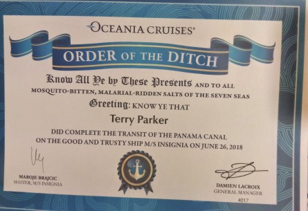
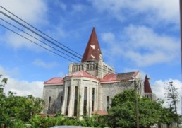
Costa Rica
Costa Rica is a familiar name. And, even if you don’t speak Spanish, you can guess it
means Rich Coast.
And that Spanish name came from, many accounts
claim, none other than Christopher Columbus, who
sailed to the eastern shores of Costa Rica during his
final voyage in 1502.
 It’s officially the Republic of Costa Rica.
Picture that map in your head. Costa Rica in
Central America, bordered by Nicaragua to the
north, Panama to the southeast, the Pacific
Ocean to the west, the Caribbean Sea to the
east, and Ecuador to the south of Cocos Island.
Not a big country. About the size of West Virginia. Or, if you
want to be more international, Denmark.
About 4.9 million people live in Costa Rica. Continuing our
comparisons, West Virginia has about 1.8 million people, and Denmark has about 5.7
million.
 When you think of Costa Rica, I’ll bet you think of
rainforests, beaches, and coffee. And they are all part of
Costa Rica’s appeal.
Coffee was first planted in Costa Rica in 1808 and soon
surpassed tobacco, sugar, and cacao as a primary export. Coffee production remained
Costa Rica’s principal source of wealth well into the 20th century, creating a wealthy
class of growers, the so-called Coffee Barons.
Costa Rica does have lots of rainforests, national
parks and protected areas. About a quarter of
its area is protected jungle. And all that
wonderful biodiversity to go with it.
 Costa Rica was a pioneer of ecotourism. By the early
1990s, Costa Rica became known as the poster child of
ecotourism.
By 2004, tourism was generating more revenue and
foreign exchange than bananas and coffee combined.
Today, Costa Rica is the most visited nation
in the Central American region with 3
million foreign visitors annually. And 49%
of the tourists are from the United States.
 And beaches. Miles of beaches on the Caribbean and the Pacific
sides of the country.
We did do some coffee tasting.
But we skipped the beaches. All the beaches we’ve seen are
becoming one big beach in my head.
And I think we’ve been jungled out. We’ve tromped through the trees, covered with mud
and sweat, hoping to see the elusive whatever. There’s never a guarantee you’ll see
anything. I think all those little birds and animals are hiding in the trees and behind the
bushes and laughing at us.
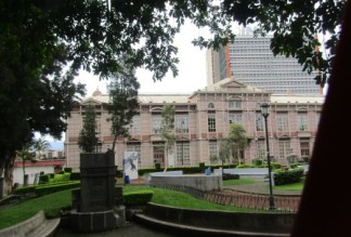
So we took a city tour. The capital and
largest city is San Jose, with about
335,000 people.
Though few people live in the city center, it is the most important working area of the
country, which brings in more than a million people daily. It’s a very busy city. With lots
of traffic.
San Jose, with its ornate Spanish colonial buildings,
sits in the Central Valley Region with the
Talamanca Mountains on the south and the
volcanos on the north.
 We toured the National Theatre which is
considered the finest historic building in the
capital. It’s known for its exquisite interior
including lavish Italian furnishings.
The Theatre sits on the Plaza de la Cultura which is a real gathering place for people.
We also went to an exhibit of Pre-Columbian artifacts,
which were amazing.
We drove through some of the 11 different
districts of the city and the barrios.
One large structure really stuck out. A new football arena. Built and paid for by China.
We have seen a lot of Chinese projects on this world cruise. China is really building up
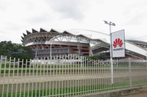 its connections worldwide. In this case, our
guide told us, China built and donated the
arena to Costa Rica, and at the next vote in the
UN on the Taiwan issue, Costa Rica voted
against Taiwan.
We saw at least six new ports being constructed or enlarged by China during our voyage. No comment.
Raiatea

Raiatea is the second largest of the Society Islands, after Tahiti, in French Polynesia.
And, remember Tahiti was in the Windward Islands.
Raiatea is in the Leeward Islands.
Raiatea has a much smaller population than Tahiti. Only 13,000 people.
But that small population makes it the most populated island in the Leewards. Yes, that means the other Leewards have hardly any  people on them.
Oh, these Windwards and Leewards
are not to be confused with the
Windwards and Leewards in the
Caribbean.
They are different. We’re still in the south Pacific, in French Polynesia.
The archipelago is believed to have been named by,
who else, Captain James Cook during his first voyage
in 1769.
He really got around.
Supposedly the name came from the Royal Society,
 the sponsor of the first British
scientific survey of the islands.
There is a small road that runs
around the entire island. We
took it.
The island economy is mainly agricultural
with exports of vanilla, pineapple and
coconut. We saw it.

Pearl farming is also an important
industry.
We stopped at a pearl farm and
visited the shop built right over the
water.
The owner gave us a quick course in seeding the pearls into the oysters. 
Then he was happy to sell us pearl
jewelry.
There is less tourism compared to
the other islands in the archipelago.
 The local tourist infrastructure
comprises a few boarding houses, two marinas, and a
port for visiting cruise ships (about
three per month, small ships).
There was a hotel with those cool-looking, thatched-
roof, over-the-water bungalows, but it closed a few
years ago.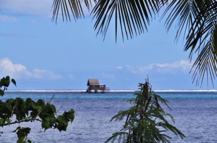
So what you do in Raiatea is
savor the beauty.
The rugged mountains make
great backdrops.
Delicate waterfalls cascade down the slopes.
 Every shade of
green is evident in
the landscape.
Brilliant blue waves
roll onto almost
empty beaches.
And the clouds provide
a constantly changing
canvas for the imagination.
What more could you want?
Somewhere in the Pacific
Travel improves your sense of geography, if you can keep it all straight.
We are in French Polynesia.
In the central Southern Pacific Ocean.

In the archipelago of the Society Islands.
In a part of the Society Islands called the Windward Islands.
Tahiti is the largest island in the Windwards.
The island of Tahiti is actually divided into two parts.

The larger, northwestern part is called Tahiti Nui.
The smaller, southeastern part is called Tahiti Iti.
The population of Tahiti is about 190,000. It is the most populous island of French Polynesia.
Actually it has over 68% of the population of all of French Polynesia.
The largest settlement on Tahiti is Papeete.
 Papeete has about 137,000 people.
So Papeete has more than 70% of the people who live on Tahiti.
The interior of Tahiti is almost uninhabited.
The island was formed by volcanic activity and is high and mountainous with surrounding coral reefs.
And, it’s famous for black sand beaches.
Tahiti was originally settled by Polynesians between 300 and 800 AD.

The island was part of the Kingdom of Tahiti until its annexation by France in 1880, when it was proclaimed a colony of France, and the inhabitants became French citizens.
And what do these inhabitants do? Chill.
Beach time rules here. No rush. I think people come here get away from life.
Our guide is from France and came here about 17 years ago for a two week vacation, and stayed.

We drove around the island, stopping at parks and beaches and gardens. It’s all beautiful. Idyllic.
Just enjoy the breeze.
American Samoa

American Samoa is the southernmost territory of the United States and one of two U.S. territories south of the Equator, along with the uninhabited Jarvis Island.
American Samoa consists of five main islands and two coral atolls.
The largest and most populous island is Tutuila, and Pago Pago is the capital.
The total land area is small, about 76.8 square miles, slightly more than Washington, D.C.

The total population is small, about 56,000 people, less than a tenth of the population of D.C.
How did Samoa become American Samoa?
Some more of that dividing up the world by the powers that be (or were).
 Those powers came up with the 1899 Tripartite Convention. Germany and the United States partitioned the Samoan Islands into two parts. The eastern island group became a territory of the United States and the western islands became German Samoa. Britain gave up all claims to Samoa and in return accepted the termination of German rights in Tonga and certain areas in the Solomon Islands and West Africa. I don’t imagine any of the divided-up areas got a vote in the negotiations.
Although technically considered “unorganized” since  the U.S. Congress has not passed an Organic Act for the territory, American Samoa is self-governing under a constitution that became effective on July 1, 1967.
 The U.S. Territory of American Samoa is on the United Nations list of Non-Self-Governing Territories, a listing which is disputed by the territorial government officials, who do consider themselves to be self-governing.
It’s a strange set up. American Samoa is the only major territory of the United States in which citizenship is not granted at birth, and people born there are considered “non-citizen nationals”.
Our guide is Samoan, born in Las Vegas! So he is American with an American passport.
After high school he moved back to Pago Pago to help the family in their tourist business. The family owned the buses we traveled around the island in. And the “village” we were taken to was his family’s compound.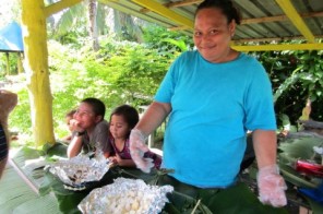
Our guide and his family aren’t unique in this effort to make tourism pay off. It seems logical since the island is beautiful and the beaches shimmering and almost empty.

There are no five-star hotels and no ritzy department stores. Although there was a KFC (KFC has been everywhere we’ve been!).
Ancestral traditions are very important. The people live in villages of their extended family with communal ownership of the land under the Matais, the chiefs of the individual families.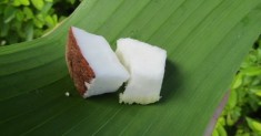
Every village has a fale, which is a guest house that looks like a big gazebo where visitors are entertained. The higher the fale, the higher the status of its owner.
 And in American Samoa, like Tonga, religion plays a major part in the lives of the people. There are lots of churches.
One unusual tradition is to bury your family members next to your home rather than in a cemetery. We saw tombs in the yards of most home as we drove around the island. They ranged from very simple to very elaborate.
Star-Kist is the major employer in American Samoa employing 75% of the Samoan work force. Wages are very low, about $5.60 an hour.
Because of economic hardship, military service has been seen as an opportunity in American Samoa. American Samoa is noted for having the highest rate of military enlistment of any U.S. state or territory. It’s a job.

Everyone was very welcoming and open. The island is beautiful and uncrowded. The water is clear and sparkling. Another island paradise.
Go before it gets overrun with tourists!
Nuku’Alofa

Tonga is officially the Kingdom of Tonga.

It’s a sovereign state and archipelago made up of 169 islands, 36 of which are inhabited.
 The total land area is about 750 square miles. But it’s scattered over 270,000 square miles of the Pacific Ocean.
All of Tonga has a population of about 107,000 people. And 70% of them live on the main island of Tongatapu.
The capital of Tonga is Nuku’alofa.
Tonga was named the Friendly Islands because of the friendly reception Captain James Cook received when he arrived on his first visit in 1773.
Cook arrived during the ‘inasi festival and was invited to the festivities.

It’s said that the chiefs wanted to kill Cook during the gathering but couldn’t agree on a plan, so Cook lived. I doubt if Cook would have called them the Friendly Islands if he had known.
Many missionary groups traveled to Tonga to convert the locals.
The Free Wesleyan Church of Tonga is the established religion in the state. About a third of the island’s population adheres to it.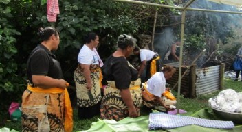
Another third of Tongans are Catholic or Mormon. A minority of worshippers form the Free Church of Tonga and the Seventh-day Adventist Church of Tonga.
 Religion is very important and never far away.
Everyday life is heavily influenced by Polynesian traditions and by the Christian faith. All commerce and entertainment activities cease on Sunday, from the beginning of the day at midnight, to the end of the day at midnight. The constitution declares the Sabbath sacred forever.
Our guide said there are over 100 churches on the island. Yes, some are pretty small.
Church takes care of the spiritual needs of the people but it is also the social hub for them.
We went to the Captain Cook’s landing site where a very small handicraft center and restaurant have been established.
The center was funded by aid from New Zealand.
 Much of the island suffered damage in a big cyclone in February of this year, and a lot of aid came from New Zealand and Australia. So we saw lots of signs indicating donations made by those two countries. And lots of demolished homes in the countryside and downed trees. But life goes on.
The women demonstrated weaving and tapa making and performed some traditional dances. Lunch was cooked on an open pit with the food wrapped in banana leaves, and then aluminum foil!
It was certainly the most low-key entertainment we’ve had. These were not professional entertainers or restaurant chefs, but the locals who are trying to make a living by sharing their traditions. They were very sincere and truly welcoming.
We drove past the royal palace and saw lots of coconut plantations.

In the village of Mu’a we visited the royal tombs. These are called langi and date back to the 13th century. They are earthen platforms with supporting stone slabs that create a pyramid effect.
We also went to Ha’amonga ‘a Maui which is called the “Stonehenge of the South Pacific”, on a much smaller scale. It’s a 13th century construction built from three slabs of coral limestone, each weighing about 40 tons. And the questions is the same, how?
Tonga is just getting into the tourist mode. We traveled on an old bus with little suspension and no a/c. With the wind whipping around us through the open windows, we arrived back to the ship looking like we had been through a cyclone but content with the quiet friendliness we had found.
Sounds
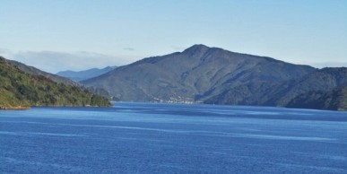
Picton is a town in the Marlborough Region of New Zealand’s South Island.
Picton’s population of about 4,500 is small, but it’s a big player in the country.
The town is located near the head of the Queen Charlotte Sound and is the usual starting point for holidays to the Marlborough Sounds. A sound?

It’s like a fjord. A narrow inlet of water typically formed by submergence of a glaciated valley. I know that because we went to the lecture by the geologist.
There was also some distinction about the steep V shape versus the more rounded curve, but I don’t remember the details so just think of it as a Norwegian fjord on vacation in New Zealand.
The sounds are beautiful. Clear, sparkling blue water. Steep forested hills dip down to the water’s edge. Many of the small bays are accessible only by boat.

New Zealanders are real outdoors people. They love the area for water sports, fishing, diving (there are several sunken vessels), biking, and hiking.
And there’s a big hike. The Queen Charlotte Track is a 45-mile bike/hike pathway that extends almost the entire length of the sound.
Picton is a major hub in New Zealand’s transport network, connecting the South Island road and rail network with ferries across Cook Strait to Wellington and the North Island.

When we walked from the dock into the town, we had to stop at the railroad tracks and wait for a train to go through.
And don’t forget the wine. Yes, this is the Marlborough wine region.

Marlborough is New Zealand’s largest wine region, producing 77% of all New Zealand wines and 90% of New Zealand’s Sauvignon Blanc. And, yes, they’re good.
We walked the downtown area. While the population is small, lots of tourists mean there are more than the average number of shops and restaurants.
I was excited to see two bookstores in such a small town!

And the residents were glad to see us. Two women met the ship and gave each of us a small handmade wildflower corsage as we got off the ship.
I don’t know if they made enough for every passenger, but they had two huge basketsful of the flowers. I said to Bob, “Think about all the work that was done to make these.” His response, “It was probably a Soroptimist project.”

The word is that the climate in Picton is always temperate at any season. I don’t know if that’s true, but our day was filled with glorious sunshine, and we didn’t even need a sweater.
Art Deco Town

Napier is located in Hawke’s Bay on the eastern coast of the North Island of New Zealand.
The population of Napier is about 63,100.
This small town is the nexus of the largest wool center in the Southern Hemisphere.

Lots of beautiful wool clothing can be bought here.
It also has the primary export seaport for northeastern New Zealand which is the largest producer of apples, pears, and stone fruit in New Zealand.
Napier has also become an important grape and wine production area, with the grapes grown in the area being sent through the Port of Napier for export.
And, Napier has become a popular tourist city, mostly for its architecture.

In 1931 the Hawke’s Bay earthquake destroyed most of the city.
The town was rebuilt with a unique concentration of Art Deco structures.
Napier is recognized with several awards for its architecture. There are also several events during each year focused on the Art Deco theme.
In keeping with the theme, you can take a tour of town riding in a classic car driven by a guide in era-appropriate attire.

Today the town sits looking out at a brilliant blue harbor.
The major street follows the shoreline.
A broad promenade separates the street and the beach.
Along the walk there are some parks and some children’s playgrounds.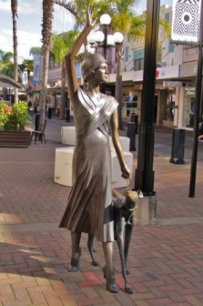
The main shopping street runs perpendicular from the beach to the mountains in the distance.
The street has been pedestrianized somewhat and landscaped with palm trees.

As with the other places we have seen here in New Zealand, everyone is pretty laid back, friendly, and in no rush. Too bad we have to rush off.
Insignia is the last ship of the season arriving in most of these towns. 
It’s fall and winter will soon be here.


There have even been some comments that they are surprised to see us so late, the last ship was a month ago.
 But they love that we are here.
Tourism is a big boost to the economy. 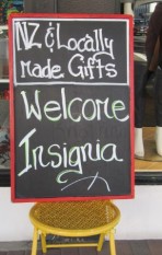
There were lots of signs in the stores welcoming us.
