Mari Mari

IMG_0001

Borneo is the largest island in Asia and the third largest island in the world.


The island is politically divided among three countries: Malaysia and Brunei in the north, and Indonesia to the south.IMG_0010 (Mobile)


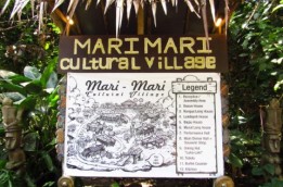
Within the Malaysian portion of the island is the city of Kota Kinabalu, or KK.


KK was a British colonial city for almost a century.  The only things that remain of the colonial era are the old post office building and the IMG_0013 (Mobile)Atkinson Clock Tower.


KK was almost totally wiped out in World War II.


Which means it was almost totally rebuilt after that and now looks like a fairly new city.IMG_0067 (Mobile)


It has grown into a financial, economic and tourism center in the region.


IMG_0073 (Mobile)The population is about 450,000.  And it has 32 ethnic groups living in the city.


But we went to see the native history.


Deep in the countryside away from KK the Mari Mari Cultural Village operates as a museum that preserves Borneo ethnic culture. It aims to share the knowledge, history, culture, and tradition of Borneo with the public so it’s not forgotten.IMG_0045 (Mobile)


The cultural village features 5 different ethnic tribes in one village.


The Kadazan-Dusun tribe were rice farmers.  Kadazan is translated “the people of the land”.


IMG_0049 (Mobile)The most important festival of the Kadazans is the Kaamatan festival or harvest festival, where they believe the spirit of the paddy is honored after a year’s harvest.


The majority of the Kadazans are Christians, mainly Roman Catholics and some Protestants. Islam is also practiced by a growing minority.IMG_0108 (Mobile)


The Rungus tribe lived in longhouses. The Rungus are formerly a sub-group of the Kadazan tribe.


IMG_0063 (Mobile)Their culture also revolves around rice, just like the Kadazan. Many Rungus now work in towns and have abandoned the communal life of the longhouse for modern Malaysian society. Traditionally they are pagans but most Rungus are now Christians.


In a traditional Rungus village, longhouses of over 75 rooms are said to have been common, which meant 75 families lived in one longhouse. Now they rarely exceed 10 rooms.


The Lundayeh tribe were hunters and fishermen.  Lundayeh means “upriver people” or “people of the interior”. They were known to be agriculturalists and had practiced livestock farming.IMG_0113 (Mobile)


In the late 1800’s to early 1900’s, the community was described as living in an unhealthy state of lifestyle.


They were hardcore burak (rice wine) drinkers, appeared to be drunk more often than not, and their houses were indescribably filthy. This filthy lifestyle caused them to be IMG_0121 (Mobile)
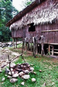
vulnerable to diseases.


In 1904 and 1905, there was a smallpox outbreak. The death toll reduced the Lundayeh population from approximately 20,000 to 3,000.


The Bajau tribe were known for two different talents.


The Bajau tribes of Kota Belud were known as “The Cowboys of The East” for their horse-riding ability.IMG_0144 (Mobile)


The Bajau Laut tribes of Semporna were known as “The Sea Gypseys” for their seafaring skills.


For many years Bajau Laut people lived in the ocean on their temporary house boats.

IMG_0159 (Mobile)Only in recent years have they made settlements into the coastal area, with their houses built on stilts.


The ocean is still their main source of living where they fish, collect clams and mussels, and even farm pearls.


The famously feared Murut tribe were headhunters.IMG_0169 (Mobile)


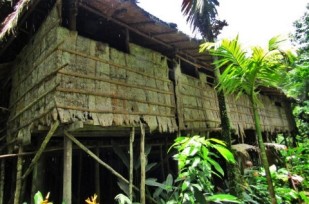
Collecting heads of enemies traditionally served a very important role in Murut spiritual beliefs.

They also utilized it to protect their village from potential enemies.

A man could only get married after he presented at least one head to the family of the desired girl.

After many were converted to Islam or Christianity and the British passed anti-headhunting legislation, headhunting by the tribe was totally banned and has disappeared.

It was a really interesting day, starting off with crossing a stream to the village on a slack swinging rope bridge.  We squeezed into dwellings made of bamboo which I couldn’t believe would hold my weight (and then we crowded 16 people in).  We climbed “steps” which were nothing more than a log with a few toe holds hatcheted out into houses raised above the ground, and, I swear, rocking in the breeze.  We slipped down debris covered paths between the villages being eyed by members of the headhunter tribe shouting and shaking their spears at us.  We stood in the rain to watch demonstrations of cooking and tool-making and head-hunting techniques.  In the end we slogged up a muddy road for a mile to drag ourselves back to the bus.  And we were smiling.


Kamikaze

We visited a second unique site in Chiran.IMG_0023

The airbase at Chiran, Minamikyūshū, on the Satsuma Peninsula of Kagoshima, Japan, served as the departure point for hundreds of Special Attack or kamikaze sorties launched in the final months of World War II.

IMG_0026 (Mobile)

A peace museum dedicated to the pilots, the Chiran Peace Museum for Kamikaze, now marks the site.IMG_0027


The Imperial Japanese Army airbase at Chiran, with its two runways, was the principal kamikaze base during the Battle of Okinawa.

IMG_0022 (Mobile)

Of the 1,036 army aviators who died in these attacks, 439 were from Chiran. Of the total number, 335 were classed as “young boy pilots”, meaning they were what we would think of as high school or college boys.  Yes, high school.  Some were as young as 15.

In 1975 a museum was built to commemorate the lives of the pilots and document their “patriotic efforts for peace”.IMG_0030 (Mobile)


Enlarged in 1986, exhibits include four planes: a Nakajima Ki-43 Hayabusa, a 1943 Kawasaki Ki-61 Hien, a 1944 Nakajima Ki-84 Hayate, and a Mitsubishi Zero recovered from the seabed in 1980.

IMG_0031

I’m sorry we weren’t allowed to take pictures inside the museum.  There were some wonderful pictures of these very young pilots leaving for their last flights.


It didn’t really make any difference whose “side” they were on.  They were leaving knowing they would not be back.IMG_0033 (Mobile)


On a personal level, the exhibit includes letters, poems, essays, testaments, and other artifacts.


The pilots wrote almost all of their “last letters” to their mothers.  They were translated into English.  Of course, they were crushingly sad, as they said goodbye and assured their IMG_0035 (Mobile)mothers they were prepared and knew they were helping their country.


There were also photographs of each of the 1,036 pilots, arranged in the order in which they died.


In a corner was the grand piano on which two of the pilots played the Moonlight Sonata the night before their final mission.IMG_0039 (Mobile)


Outside we were able to walk through one of the buildings that housed the sleeping quarters of the pilots.  Simple cots lined up, the beds made, the pillows squared up, ready for the occupants’ return.


The grounds held several memorial sites.


The Tokkō Kannondō is a temple dedicated to the “Special Attack Goddess of Mercy”.  The image enshrined within is a 1.8m replica statue of the Yumechigai Kannon, the Dream-Changing Kannon.  The names of the kamikaze pilots are written on paper within her womb.

IMG_0041 (Mobile)
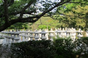
Stone lanterns dedicated to the pilots line the approach to the museum.  Each lantern is numbered, one for each of the 1,036 army kamikaze to die in the battle for Okinawa at the end of the war


It was a moving memorial to a country’s last-ditch efforts in a war where all sides sacrifice.


Samurai Village

Forget what you “learned” in Tom Cruise’s Last Samurai movie.  There was never an American samurai.1523928643775


The Edo or Tokugawa Period (1603 to 1868) is often referred to as Pax Tokugawa, “The Tokugawa Peace”, because it brought to an end the almost incessant warfare between rival warlords that had for several centuries embroiled Japan to the extent that the period is 1523602873788known as The Warring States Period.

This new found peace and stability was achieved by a series of controls placed on the warlords by the new Shogunate.

The most well known control was the sankin kotai system that stipulated that each daimyo (feudal lord) must maintain a residence in Edo (Tokyo) and live there in alternate years. 1523946574251


When back in their home domains their families would remain in Edo as hostages. This led to Edo becoming one of the biggest cities in the world.

IMG_0057

Another control was that each domain could only have one castle, and the samurai must live in the vicinity of the castle.

Samurai were the professional warriors bound to an overlord much like knights in medieval Europe.


In the Kagoshima Prefecture at the far southern end of Kyushu, in the Shimazu clan’s domain of Satsuma, they chose to do things a little differently.

Instead of bringing in all their samurai to one central location they did the opposite. They dispersed the samurai all over the domain.IMG_0061


Across Japan as a whole the samurai made up about 10% of the population, but in Satsuma it was more like 40%.  Of course this was technically IMG_0068illegal, but the shogunate seems to have ignored it.


We visited Chiran which was home to more than 500 samurai residences during the late Edo period.IMG_0064


Today some of the original preserved buildings form a museum complex. with seven gardens open to the public.


IMG_0063 (Mobile)
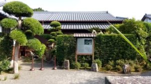
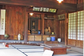
The uniqueness of the Chiran Samurai Residence Complex lies in the stonewall-lined paths, the scattered Samurai houses and the beautifully landscaped gardens within.IMG_0004 (Mobile)


The complex was built with defense purposes in mind.  The paths are neither too wide nor too narrow.  There are many corners and bends to reduce visibility of potential invaders.


IMG_0001
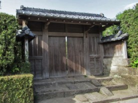
The hedges behind the stone walls of the houses are pruned in such a way that someone inside the house can see the outside clearly, but not the other way around.  It’s possible to ambush invaders with arrows and spears without exposing the attacker’s location.


The gardens are officially recognized as a “National Scenic Beauty” spot.IMG_0007 (Mobile)


The garden of the Mori family is the only one built in the “Tsukiyama Sensui” style, with rocks laid out to represent the mountain, and an actual pond filled with water.


The other six gardens are built in the “Karesansui” (dry garden) style, using Shirasu (pumice and volcanic ash IMG_0010 (Mobile)commonly found in the south Kyushu region) spread out across the garden grounds to represent water surface.


It was a beautiful setting.  As usual, we wished we had been able to spend more time there.


Smoking Kagoshima

We cruised into Kagoshima, past Volcano Sakurajima.IMG_0003 (2)

Sakurajima is an active composite volcano.

It used to be an island.  The lava flows in the 1914 eruption connected it with the Osumi Peninsula.

The most recent eruption started on May 2, 2017.

We saw it on April 12, 2018.  It was smoking.  Not a lot.

Sakurajima is a stratovolcano.   That’s the classic volcano shape.  It drops ash on itself and builds a cone.

Its summit has three peaks, Kita-dake (northern peak), Naka-dake (central peak) and Minami-dake (southern peak).  Minami-dake is active now.

IMG_0004 (6)
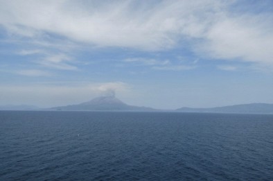
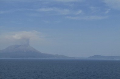
For full disclosure, the second picture was taken through one of the ship’s windows.  That’s why it’s so blue.  But I liked the effect, and it makes the less-than-thrilling action on the peak a little more exciting!

Descending Dragon

Ha Long Bay is in the Gulf of Tonkin, in northern Vietnam, near the border with China.IMG_0022 (3)


The bay holds a dense cluster of 1,969 monolithic limestone islands that jut up from the ocean, most topped with thick vegetation.

IMG_0025 (3)

These limestone islands are known as “karst”.


About half the islands, 989, have been given names.IMG_0027 (3)


Many are named because of their shape – elephant, fighting cock, tortoise, or man head.


IMG_0030 (3)


Other names are more fanciful – Heavenly Gate, Isle of Wonders, Tea Pot Rock, and Devil’s Face.


The bay was listed as a World Heritage site by UNESCO in 1994.IMG_0038 (3)


Ha Long Bay means “Bay of the Descending Dragon” in Vietnamese.


Local legend says long ago when the forefathers were fighting foreign invaders from the north, the gods from heaven sent a family of dragons to help defend IMG_0042 (3)their land.


The family of dragons descended on Ha Long Bay and began spitting out jewels and jade.


When the jewels it the water, they turned into the various islands and islets and formed a fortress against the invaders.IMG_0051 (2)


The dragon family fell so much in love with the area for its calm water and the reverence of the people of Vietnam that they decided to remain on earth.


We came into the bay late in the afternoon through a fog.IMG_0077 (2)


IMG_0078 (2)


There were no other sounds as we glided slowly


bIMG_0080 (2)etween the islands.


It’s easy to see how stories of mystery

and the supernatural grew in a place like this.


Ho Chi Minh City

What did we expect Saigon to look like?IMG_0001

We knew it wouldn’t look like all those

evening news reports from the 1970s or

the movies about the “American War” as

the Vietnamese call it.

IMG_0002

And we should have been

prepared for it to look like

almost all the ports we have

visited, huge, modern, crowded, bustling.IMG_0007 (4)


The Ho Chi Minh City metropolitan area has over 9

million people.  And growing.

IMG_0016

The city is packed with cars.  Even more so

with motorscooters.  There are motorbike

taxis called “see ohms”.  Uber has one

company.  Another is called “Grab”.

The tour we took, of course, focused on the time of the Vietnam Conflict.  Except for a

stop at a lacquer ware “factory” and “showroom” in case someone needed someIMG_0002 (Mobile)

souvenirs.

We visited the Reunification Palace

which is now a museum.  The building

was the headquarters for the

president of South Vietnam.

IMG_0001On April 30, 1975, North Vietnamese tanks breached the

palace’s gates.  There’s still a tank parked in the grounds.

The Central Post Office, built between 1886 and 1891, is

one of the oldest buildings in Ho Chi Minh City.  It was

designed by Gustave Eiffel, of Tower fame.

And the post office is right across the street from the Notre

Dame Cathedral.

The cathedral was built between 1877 and 1880 by French colonists and modeled after

the Notre Dame Cathedral in Paris.

The old American Embassy was demolished in 1995, but the guide pointed out the old

building where the CIA was housed so we could be sure to take pictures of the rooftop

made famous at the fall of Saigon.IMG_0005 (2)

We made a stop at the Giac Lam Pagoda, the oldest temple

in Ho Chi Minh City.  It’s unique because here Taoism and

Confucianism merge with Buddhism.  More unique, we

thought, was an alter dedicated to Ho Chi Minh.

IMG_0027 (2)Our day ended with a

trip through Chinatown, founded by Chinese

immigrants in 1780.


And then, of course, the obligatory shopping stop at “one of the most colorful and

exciting markets in the city, Binh Tay”.   Oops I forgot to take a picture there.  Just refer

back to some other market stop.

Grand Palace

Bangkok is the capital of the Kingdom of Thailand.IMG_0002


The city is spread out over 605 square miles.


Bangkok has a population of over 8 million, which is

more than 12.6 percent of the country’s population.

IMG_0104

IMG_0096


Over 14 million people live within the surrounding

Bangkok Metropolitan Region which means this is a really

packed area.

IMG_0004 (Mobile)

IMG_0005 (Mobile)
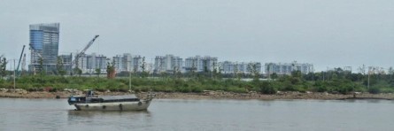
The city is now a major regional

force in finance and business and

an international hub for transport

and health care.  Bangkok has

emerged as a regional center for

the arts, fashion and

entertainment.

The biggest tourist attraction is the historic Grand Palace.IMG_0021

IMG_0019 (Mobile)


The Grand Palace was built in 1782.  It is a walled complex

covering more than a square mile.  No wonder we were so tired after spending half a day

here.

IMG_0026 (Mobile)
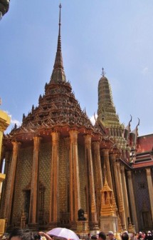
For 150 years the Palace was the home of the

Thai King, the Royal court and the

administrative seat of government.  Within

its walls were also the Thai war ministry,

state departments, and even the mint.IMG_0029 (Mobile)


IMG_0053 (Mobile)


While the King no longer lives in the palace, the palace complex is still used to mark all

kinds of other ceremonial and auspicious happenings.


IMG_0061

And the complex remains the spiritual heart of the Thai

Kingdom.  Within the Palace complex is the Wat Phra

Kaeo.IMG_0083

This temple enshrines the

renowned Emerald

Buddha.


Today, and every day, the Palace is swamped with tourists

agog at the beautiful architecture and intricate details covering the buildings.IMG_0079


Hot, 94 degrees.  Humid, 90%.  The sun beating down.  Many

carried umbrellas, as sun protection not rain protection.  We

hid under wide-brimmed safari hats.


We, once again on this trip, were soaked with sweat, all theIMG_0001

way through.  And queasy with the heat.  We had

already gulped down two liters of water, each. The only

thing to do was finish the tour with ice cream.

Singapore

Stamford Raffles founded colonial Singapore in 1819 as a trading post of the British East India Company.  When the company collapsed in 1858, the islands became a BritishIMG_0065 crown colony.


Singapore gained independence from the UK in 1963 by joining with other British territories to form Malaysia.  Two years later Singapore separated from Malaysia and became a sovereign nation.

IMG_0070 (Mobile)

Singapore is still a trading post of sorts and is a booming city.  The Singaporean economy is known as one of the freest, most innovative, most competitive, most dynamic and most business-friendly.  The city is covered with new skyscrapers and cranes building even more.IMG_0004


Singapore ranks 5th on the UN Human Development Index and the 3rd highest GDP per capita. It is ranked highly in education, healthcare, life expectancy, quality of life, personal safety and housing.

IMG_0074 (Mobile)


Singapore has the world’s highest percentage of millionaires, with one out of every six households having at least one million US dollars in disposable wealth! It also has one of the highest income inequalities among developed countries.


Even though income inequality is high, 90% of homes are owner-occupied.  How can that be?  Because more than 80%IMG_0003 live in subsidized, high-rise, public housing apartments that they buy from the government.


But most people don’t own cars.  Singapore is a small island so to discourage vehicle ownership there is a 100% special tax on new vehicles.

IMG_0004

To buy a car you have to register with a dealership which participates in an auction IMG_0024 (Mobile)


to make the purchase.  And there are only a certain number of “winners” per year.


IMG_0033There is a congestion fee drivers must pay to go into the Central Business District, and at times there are surge prices on taxis to further limit downtown congestion.


Singapore has been consistently rated among the least corrupt countries in the world.

Our guide said that the government officials are paid very well so they can’t be corrupted.   He gave the example of the President of the country, who happens to be a female (Halimah Jacob, the first female President) and a Muslim (only 14% of the population is Muslim), who makes $3 million a year.  And he said all she has to do is say “No”.  Parliament passes the laws.  She can veto the law three times.  That’s it.IMG_0067


And the law is a little different than our law.  There is no trial by jury.  Penalties can be severe, including caning, which may be imposed for such offences as rape, rioting, vandalism, and certain immigration offences. There is capital punishment for murder, aggravated drug-trafficking and firearms IMG_0002offenses.


Every place has its positives and negatives.


We went to a lot of different areas of town including Chinatown and the famous Orchard Street shopping area and saw lots including temples and historical landmarks.


But perhaps the most impressive feature was the Marina Bay Sands “integrated resort” which stretches across the top of three skyscrapers.  IMG_0026It cost something like $8 billion.


If you look at the photo closely you can see the palm trees on the top, by the infinity swimming pool.  Singapore.


Intelligent Garden City

Kuala Lumpur is the capital of Malaysia.  It has 7.6 million people.  It’s jammed-packed and has horrible traffic.

Because of the overcrowding and congestion, the government decided to build a new federal administrative center outside of Kuala Lumpur.

IMG_0059

In 1999 the seat of government was moved to Putrajaya, officially the Federal Territory of Putrajaya, a new planned city about 20 miles from K.L.

K.L. is still Malaysia’s national capital and the seat of the King, Parliament, all foreign embassies, and the country’s commercial and financial center.IMG_0061

The city is named after the first Malaysian Prime Minister, Tunku Abdul Rahman Putra.  In Sanskrit, “putra” means “prince” or “male child”, and “jaya” means “success” or “victory”.

IMG_0060The city covers approximately 19 square miles.  Planned as a garden city and intelligent city, 38% of the area is reserved for green spaces. The city surrounds a beautiful man-made lake.  Putrajaya Botanical Gardens is the biggest botanical garden in Malaysia, covering an area over 250 acres.IMG_0070 (Mobile)

Construction began in August 1995.  It was Malaysia’s biggest project and one of Southeast Asia’s largest, with an estimated final cost of $8.1 billion.

The entire project was designed and constructed by Malaysian companies with only 10% of the materials imported.

IMG_0069A new highway connects Putrajaya with K.L. and the port.  The Kuala Lumpur–Singapore High Speed Rail will also connect to Putrajaya and there are plans for a monorail system within Putrajaya.


The Putrajaya Corporation provides its own bus services using natural gas-powered buses. Oh, and, Putrajaya is home to the world’s largest roundabout, the Persiaran Sultan Salahuddin Abdul Aziz Shah with a perimeter of 2.7 miles!  It’s so big, we didn’t realize we were on it.IMG_0043

The population is approximately 90,000, mostly government employees who have been encouraged to relocate to the city through a variety of government subsidy and loan programs.

IMG_0047 (Mobile)Those are all the facts I can remember.  Now, what I saw.


Since everything is new, it’s beautiful and sparkling.  The immense, green-domed Perdana Putra contains the prime minister’s office complex.IMG_0058 (Mobile)


Even more striking is the Putra Mosque, made from rose-colored granite with a pink dome.

IMG_0051 (Mobile)

It’s huge and a tourist attraction in addition to being a very well-used place of worship.  Something like 98% of the population of Malaysia is Muslim.IMG_0052 (Mobile)


The Palace of Justice looks just like a palace of justice should.

IMG_0074 (Mobile)
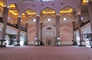
All around are other beautiful governmental buildings.  The Ministry of Finance.  The Malaysian Ministry of Foreign Affairs.

There’s an International Convention Centre and a Leadership Foundation.

And housing, both high rise apartments and single family dwellings (for the higher up government officials, of course).

There are schools and even a university branch.  And, of course, commercial and retail space.

The place really stands out.  But then it’s a from-scratch city built with almost unlimited money.  I wonder what we would do in that situation?


House of Peace

Dar es Salaam is Arabic for “the house of peace”.

In the 19th century the city was called Mzizima which means “healthy town” and was just a coastal fishing village on the periphery of Indian Ocean trade routes.Dar es Salaam

In 1865 Sultan Majid bin Said of Zanzibar began building a new city very close to Mzizima and named it Dar es Salaam.  Dar es Salaam fell into decline after Majid’s death in 1870, but was revived in 1887 when the German East Africa Company established a station there.

IMG_0018German East Africa was captured by the British during World War I and became Tanganyika, with Dar es Salaam remaining the administrative and commercial center, under British indirect rule.

Tanganyika attained independence from colonial rule in December 1961.IMG_0027

Today Dar es Salaam is the largest city in Tanzania, East Africa, and is Tanzania’s most prominent city in arts, fashion, media, music, film and television and a leading financial center.

IMG_0031

The city is the leading arrival and departure point for most tourists who visit Tanzania.  Most of those tourists fly in on their way to safaris.  Only about 5 cruise ships stop per year.

The region has a population of 4.4 million.  The city is one of the fastest growing cities in the world.  And it has the traffic to prove it.

We didn’t expect any of this.old fort

And we actually didn’t do any real touring in the city.  We headed for Bagamoyo (44 miles north of town), with a police escort for the bus.  While in West Africa we always had armed security on the tour buses, here our police escort was not for security (they told us) but to get us through traffic.  And we believed it.  Traffic was at a standstill in many places, even after we left the city proper.  But our motorcycle police officer in front with lights and siren blaring got traffic to pull over and let us pass.  Pedestrian traffic stopped, too, to see what dignitaries were speeding by.  Children waved.  Adults just stared. As another person on the bus said, we never felt so white.

IMG_0069

The first thing we visited in Bagamoyo was the settlement of Kaole.  Actually, the ruins of Kaole.


The stone ruins contain the remains of two mosques and 30 tombs built from coral stones dating back to the 13th century.


The area acquired the name Bagamoyo by the 18th century and was an important stop in the caravan trade.  The name means “take the load off and rest”.

IMG_0112Bagamoyo was also a starting point for famous European explorers like Richard Francis Burton, John Hanning Speke, Henry Morton Stanley, andIMG_0099 James Augustus Grant.


Although David Livingstone never came to Bagamoyo during his lifetime, after his death in Zambia, his attendants removed his heart and buried it under a tree near the spot where he died and transported his body to Bagamoyo.  His body was laid out in the Old Church’s tower (now IMG_0109called Livingston Tower) to wait for high tide to come in and ship his body to Zanzibar.

The Old Fort was built by Abdallah Marhabi in 1860.  In the 19th century the Germans took control of it, using it to defend the East African coast.Boma01

In 1897 the German Boma was built as the German colony’s central administrative office.

After reading through this post I was afraid I gave the wrong impression of Tanzania.  Yes, Dar es Salaam is booming.  But the country as a whole is not.  More than 65% of the population in Tanzania lives below the poverty line.  As soon as you start to drive out of Dar es Salaam, you see the striking difference.  There is a big disparity in wealth between urban and rural areas.  Our lecturer on the ship has said several times that once more than 50% of a country’s population is urban, the country is classified as developing.  Tanzania isn’t there yet.  Hopefully, the economic growth in Dar es Salaam will spread to the rest of the country without much delay.